All About Google’s AI Powered Virtual Satellite Imagery
Satellite imaging is used everyday to provide scientists and experts with a close to real-time view of the planet.
The complexity of this data has created a new challenge of connecting differing datasets and using them all effectively.
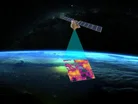
Google has launched its AlphaEarth Foundations, an AI model that functions like a virtual satellite, with the aim to help scientists make more informed decisions on critical issues impacting the earth.
Kate Brandt, Chief Sustainability Officer at Google said on Linkedin: “Today we’re launching a new AI model, AlphaEarth Foundations, to help understand our planet in magnificent detail.
“Now, with just a few lines of code, researchers and governments can do complex analysis with machine learning to create maps for urban expansion, agriculture and clean energy planning.
“Groups like the United Nations FAO and MapBiomas are already using it to create powerful custom maps and drive real-world insights.”
How is AlphaEarth Foundations going to be useful?
The AI powered satellite will characterise the planet's terrestrial land and coastal waters, doing this by integrating huge amounts of earth observation data into a digital representation.
This will provide scientists with a more complete picture of the planet's evolution, allowing them to make better decisions related to food security, deforestation, urban expansion and water resources.
The technology highlights areas of agriculture that aren’t visible to the naked eye, assigning the colours red, green and blue to further detail agricultural plots and map out complex surfaces, like in Antarctica an area known to be difficult to capture due to irregular satellite imagery.

The software has been tested on more than 50 organisations in the last year, to see it applied to the real world.
With partners reporting to Google that they are already seeing benefits, using the data to classify unmapped ecosystems, understand agricultural and environmental changes and greatly increasing the accuracy and speed of mapping work.
Inside AlphaEarth Foundations
The technology provides a new lens, boosting understanding the planet by solving two major challenges, data overload and inconsistent information.
It collects and combines information from different public sources including optical satellite images, radar, 3D laser mapping, climate solutions.
Utilising all this information it analyses the world’s land and coastal waters in high resolution images, which allows the tech to track changes over time.
The system then has the ability to compact a summary for each image, Google reports that AlphaEarth Foundations also requires 16 times less storage space than other AI systems, reducing the cost of the planet analysis.
Google says that now scientists no longer need to rely on a single satellite passing overhead to create detailed maps of the world.
Now they can do things like monitor crop health, track deforestation and observe construction on demand.
Lila Ibrahin Chief Operating Officer at Google said on Linkedin: “For years, we've had vast amounts of satellite data, but it's often complex and disconnected.
“Our new AI model—Alpha Earth Foundations—can weave that data together into a single, detailed map, giving us an unprecedented understanding of our world.
“By enabling a more complete & consistent picture of our world, AlphaEarth Foundations has amazing potential to do things like:
• "Help researchers track deforestation
• "Empower communities to manage vital water resources
• "Enable easier monitoring of crop health to support global food security
“It’s powerful to see our research move from the lab to real-world applications that matter.
“Congratulations to the AlphaEarth Foundations team on this impactful work!”
Real world application of AlphaEarth Foundations
Global Ecosystems Atlas is an initiative that is aiming to monitor the world’s ecosystems by creating a comprehensive resource map.
The company is using the AI powered dataset to help countries classify untapped ecosystems into categories like coastal shrubland and hyper-arid deserts.
The resources it produces will help countries prioritise conservation areas, optimise restoration efforts and combat the loss of biodiversity.
Nick Murray, Global Science Lead of Global Ecosystems Atlas says: “The Satellite Embedding dataset is revolutionizing our work by helping countries map uncharted ecosystems - this is crucial for pinpointing where to focus their conservation efforts.”